Monday, October 5, 2009

List of largest cities in Brazil

List of largest cities in Brazil

From Wikipedia, the free encyclopedia

Jump to: navigation, search
This is a list of the largest cities in Brazil. Brazil has a relatively high reported level of urbanization, with 8 out of every 10 Brazilians living in cities. The criteria used by the IBGE (Brazilian Institute of Geography and Statistics) in determining whether households are urban or rural, however, is based on political divisions, not on the built environment.
A town is any seat of a district (the lowest political division); a city is the seat of a municipality. Nowadays, the country has more than 5,564 municipalities.[1] About 81.3% of Brazilians live in an urban area.also known as the ghettos. where mostly the colored or "choco" people of brazil are found.[2]
State capitals are also each the largest city in its state, the exceptions being Vitória in Espírito Santo, and Florianópolis, the capital of Santa Catarina; there are also non-capital metropolitan areas in São Paulo (Campinas, Santos, Paraíba Valley), Minas Gerais (Vale do Aço), Rio Grande do Sul (Sinos Valley), and Santa Catarina (Joinville & Itajaí Valley). Most of the non-capital large cities in Brazil are in the states of São Paulo, Minas Gerais, Santa Catarina and Paraná.
Few of the principal Brazilian cities are planned cities; the most famous of these is a city called Brasília, which represents the Modernist school of architecture and urbanism.

Contents

[hide]

[edit] Top 100 most populous cities

8 - Manaus
9 - Recife
13 - Goiânia
17 - Maceió
21 - Natal
22 - Teresina
This list of the 100 most populous cities is based on the population of the município where the city is located, rather than its metropolitan area.
IBGE estimatives of 2009 [3]
State capitals are in bold
Rank  ↓ City  ↓ State  ↓ Population  ↓
1 São Paulo  São Paulo 11.037.593
2 Rio de Janeiro  Rio de Janeiro 6.186.710
3 Salvador  Bahia 2.998.056
4 Brasília  Distrito Federal 2.606.885
5 Fortaleza  Ceará 2.505.552
6 Belo Horizonte  Minas Gerais 2.452.617
7 Curitiba  Paraná 1.851.215
8 Manaus  Amazonas 1.738.641
9 Recife  Pernambuco 1.561.659
10 Belém  Pará 1.437.600
11 Porto Alegre  Rio Grande do Sul 1.436.123
12 Guarulhos  São Paulo 1.299.283
13 Goiânia  Goiás 1.281.975
14 Campinas  São Paulo 1.064.669
15 São Luís  Maranhão 997.098
16 São Gonçalo  Rio de Janeiro 991.382
17 Maceió  Alagoas 936.314
18 Duque de Caxias  Rio de Janeiro 872.762
19 Nova Iguaçu  Rio de Janeiro 865.089
20 São Bernardo do Campo  São Paulo 810.979
21 Natal  Rio Grande do Norte 806.203
22 Teresina  Piauí 802.537
23 Campo Grande  Mato Grosso do Sul 755.107
24 Osasco  São Paulo 718.646
25 João Pessoa  Paraíba 702.235
26 Jaboatão dos Guararapes  Pernambuco 687.688
27 Santo André  São Paulo 673.396
28 Uberlândia  Minas Gerais 634.345
29 Contagem  Minas Gerais 625.393
30 São José dos Campos  São Paulo 615.871
31 Feira de Santana  Bahia 591.707
32 Sorocaba  São Paulo 584.313
33 Ribeirão Preto  São Paulo 563.107
34 Cuiabá  Mato Grosso 550.562
35 Aracaju  Sergipe 544.039
36 Juiz de Fora  Minas Gerais 526.706
37 Aparecida de Goiânia  Goiás 510.770
38 Londrina  Paraná 510.707
39 Ananindeua  Pará 505.512
40 Belford Roxo  Rio de Janeiro 501.544
41 Joinville  Santa Catarina 497.331
42 Niterói  Rio de Janeiro 479.384
43 São João de Meriti  Rio de Janeiro 469.827
44 Betim  Minas Gerais 441.748
45 Campos dos Goitacazes  Rio de Janeiro 434.008
46 São José do Rio Preto  São Paulo 419.632
47 Mauá  São Paulo 417.458
48 Santos  São Paulo 417.098
49 Vila Velha  Espírito Santo 413.548
50 Caxias do Sul  Rio Grande do Sul 410.166
51 Florianópolis  Santa Catarina 408.161
52 Serra  Espírito Santo 404.688
53 Diadema  São Paulo 397.738
54 Olinda  Pernambuco 397.268
55 Carapicuíba  São Paulo 392.701
56 Campina Grande  Paraíba 383.764
57 Porto Velho  Rondônia 382.829
58 Mogi das Cruzes  São Paulo 375.268
59 Piracicaba  São Paulo 368.843
60 Macapá  Amapá 366.484
61 Cariacica  Espírito Santo 365.859
62 Montes Claros  Minas Gerais 363.227
63 Bauru  São Paulo 359.429
64 Itaquaquecetuba  São Paulo 359.253
65 Jundiaí  São Paulo 349.929
66 Ribeirão das Neves  Minas Gerais 349.307
67 Pelotas  Rio Grande do Sul 345.181
68 Anápolis  Goiás 335.960
69 Maringá  Paraná 335.511
70 Caucaia  Ceará 334.364
71 Canoas  Rio Grande do Sul 332.056
72 Franca  São Paulo 330.938
73 São Vicente  São Paulo 330.795
74 Foz do Iguaçu  Paraná 325.137
75 Vitória  Espírito Santo 320.156
76 Paulista  Pernambuco 319.373
77 Vitória da Conquista  Bahia 318.901
78 Petrópolis  Rio de Janeiro 315.119
79 Ponta Grossa  Paraná 314.681
80 Guarujá  São Paulo 308.058
81 Rio Branco  Acre 305.954
82 Blumenau  Santa Catarina 299.416
83 Caruaru  Pernambuco 298.501
84 Uberaba  Minas Gerais 296.261
85 Cascavel  Paraná 296.254
86 Petrolina  Pernambuco 285,339
87 Suzano  São Paulo 284.356
88 Limeira  São Paulo 281.583
89 São José dos Pinhais  Paraná 279.297
90 Santarém  Pará 276.665
91 Taubaté  São Paulo 273.426
91 Barueri  São Paulo 270.173
93 Gravataí  Rio Grande do Sul 269.446
94 Santa Maria  Rio Grande do Sul 268.969
95 Boa Vista  Roraima 266.901
96 Governador Valadares  Minas Gerais 263.274
97 Volta Redonda  Rio de Janeiro 261.403
98 Viamão  Rio Grande do Sul 260.740
99 Novo Hamburgo  Rio Grande do Sul 257.746
100 Juazeiro do Norte  Ceará 249.829

[edit] Largest metropolitan areas

Currently, as of 2009, IBGE officially recognizes 15 major RMs (Região Metropolitana; Metropolitan Region in English), where approximately 32% of the Brazilian population (55 million people out of 180 million) live. These RMs are responsible for approximately half of the Brazilian GDP and more than 70% of the Brazilian annual industrial production.
IBGE estimatives of 2009 [3]
6 - Recife

Rank  ↓ Metropolitan Area  ↓ State  ↓ Population  ↓
1 São Paulo  São Paulo 19,889,559
2 Rio de Janeiro  Rio de Janeiro 11,812,482
3 Belo Horizonte  Minas Gerais 5,397,438
4 Porto Alegre  Rio Grande do Sul 4,063,886
5 Salvador  Bahia 3,967,902
6 Recife  Pernambuco 3,787,667
7 Fortaleza  Ceará 3,602,319
8 Brasília  Distrito Federal,  Minas Gerais and  Goiás 3,451,549
9 Curitiba  Paraná 3,172,357
10 Campinas  São Paulo 2,633,523
11 Belém  Pará 2,078,405
12 Goiânia  Goiás 2,007,868
13 Manaus  Amazonas 2,006,870
14 Vitória  Espírito Santo 1,624,837
15 Santos  São Paulo 1,606,863
16 Natal  Rio Grande do Norte 1,255,409
17 São Luís  Maranhão 1,211,270
18 Maceió  Alagoas 1,111,678
19 Teresina  Piauí and  Maranhão 1,092,721
20 João Pessoa  Paraíba 1,077,944
21 Cuiabá  Mato Grosso 815,392
22 Petrolina and Juazeiro  Pernambuco and  Bahia 812,515
23 Aracaju  Sergipe 759,998
24 Londrina  Paraná 759,533
25 Maringá  Paraná 570,094
26 Vale do Aço  Minas Gerais 449,340
27 Macapá  Amapá 454,753

Ahipara free encyclopedia

Ahipara

From Wikipedia, the free encyclopedia

Jump to: navigation, search
Ahipara
Ahipara is located in Northland
Ahipara
Coordinates: 35°10′17″S 173°9′12″E / 35.17139°S 173.15333°E / -35.17139; 173.15333
Country New Zealand
Region Northland Region
District Far North District
Population (2006)
 - Total 1,125
Ahipara Bay
W

Ahaura free encyclopedia

Ahaura

From Wikipedia, the free encyclopedia

Jump to: navigation, search
Ahaura
Ahaura is located in West Coast
Ahaura
Ahaura
Coordinates: 42°20′54″S 171°32′26″E / 42.34833°S 171.54056°E / -42.34833; 171.54056
Country New Zealand
Region West Coast
District Grey District
Population (2006)
 - Total 390
Ahaura is a town in the West Coast region of New Zealand's South Island, sited where the Ahaura River flows into the Grey River. State Highway 7 and the Stillwater - Westport railway line pass through the town. Greymouth is 34 km to the south-west, and Reefton is 44 km to the north-east.[1][2]
The population of the Ahaura statistical district, which covers a much larger area than the town, was 390 in the 2006 Census, a decrease of 21 from 2001.[3].
European settlement of the area began with the establishment of a pastoral run near the junction of the Ahura and Grey Rivers in 1858.[4]

[edit] Education

Awahono School - Grey Valley is a coeducational full primary (years 1-8) school with a decile rating of 4 and a roll of 119.[5] The school was formed at the beginning of 2005 from the merger of Ahaura, Moonlight, Ngahere and Totara Flat schools.[6]

List of towns in New Zealand

List of towns in New Zealand

From Wikipedia, the free encyclopedia

Jump to: navigation, search
This is a list of towns in New Zealand. The term "town" has no current statutory meaning in New Zealand, the few "Town Districts" having been abolished in 1989 or earlier.
No particular size minimum has been adopted. Many would be called "villages" in other countries. The towns include most urban areas in New Zealand. For convenience, cities are included, marked in bold. Isolated towns, such as Ashburton and Levin, are usually parts of a local government "District" (which occasionally has the same name), but the rest, such as Wainuiomata, Pukerua Bay, and Port Chalmers, are within city council boundaries. Many were boroughs during most of the twentieth century, and some earlier.

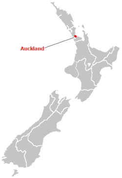
Newzeland/Auckland city.

The name Auckland refers both to a region and a city. The Auckland region stretches from Wellsford in the north to the Bombay Hills to the south, and from the wild expansive west coast beaches on the Tasman Sea, to the white sand coastline of the mighty Pacific Ocean to the east.

AUCKLAND HOTELS
Check in:
Check out:
Advanced search
Auckland city is centred within this region and is actually one of the biggest cities in the world in area, over twice the size of London. The population is a lot less, so it is not common to experience crowds or cramped conditions. Auckland contains just under one third of the total population of New Zealand and is also the largest Polynesian city in the world, as it attracts many Maori, as well as islanders from the South Pacific.
Auckland Night Skyline photoAuckland's twin city is Sydney in Australia and if you have been to Sydney, it is not hard to see the similarities. Auckland (like Sydney) has a spectacular harbour complete with nice beaches (25 in all), a huge tower, a harbour bridge, and an area north of the bridge called the North Shore. But Auckland is also unique. One of the main geographical features in Auckland are the 50 or so volcanic cones that are dotted in and around the city's suburbs. The more known volcanos include Mt Victoria, Mt Albert, Mt Wellington and the most famous of all, One Tree Hill. These Volcanic cones offer the best views of Auckland as they rise abruptly from the undulating landscape below.
Auckland location mapAuckland has been dubbed the "City of Sails" and boasts more boats per head of capita than any other city in the world. The city has held 2 Americas Cup events and you can wine and dine at any number of superb restaurants, cafes, and bars along the harbour to service the yachting and dining culture.
Auckland's North Shore, contains many of the best beaches and is also one of the more favoured places to live. West Auckland is is situated conveniently near the rugged west coast beaches with some beautiful suburbs located in the densely forested Waitakere Ranges. South Auckland near the airport contains some industrial areas and sprawling suburbs including Manukau City which has been inundated by the sprawling mass of Auckland suburbia.
Takapuna on the North Shore is a popular shopping area in the summer and is conveniently located next to a beach of the same name. The most popular shopping area in Auckland is New Market which has every type of shop imaginable including hundreds of stores from top designer labels.
Auckland city is continuing to grow at a rapid rate and guarantees that this region stays the most populous area in New Zealand.